|
|
|
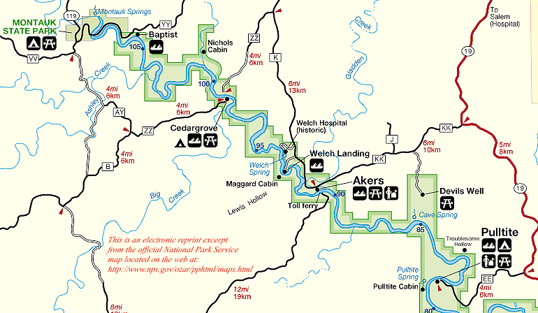
This is an enhanced
electronic excerpt reprint from the official National Park Service
"Ozark National Scenic Riverways Park" map located on the web at: http://www.nps.gov/ozar/pphtml/maps.html. |
-
- Current River
- Difficulty: I, occasionally II.
- Gradients: General -- 4.4; Montauk to Akers -- 8.7; to junction of Jacks Fork -- 5;
- to Big Spring -- 3.8; to Doniphan -- 3.2.
- THIS MAP
- 0.0 Montauk State Park: camping, meals, lodging, fish hatchery, trout fishing, springs. No access.
- 0.9 Tan Vat access.
- 2.1 Baptist Camp Access.
- 4.3 Ashley Creek on right.
- 7.5 Parker Hollow on left, fed by Schafer Spring 1.2 miles upstream.
- 9.0 Cedargrove: low-water bridge, campground, put-in.
- 9.9 Big Creek on right.
- 12.6 Medlock Cave and Spring on right. Cave contains lake. Entrance good shelter.
- 13.7 Welch Spring and Cave on left. Cave stream and lakes have been traversed by canoe. Spring sixth largest in state.
- 16.7 Akers Ferry (Hwy. K) and put-in. Good camp area upstream from ferry on left. Large sinkholes known as "The Sunkland" and "Burr Oak Basin," 3 to 4 miles south of Akers, may be reached on foot via Lewis and Hieronymus Hollows.
- 18.8 Lewis Hollow on right (at ford).
- 21.9 Cave Spring and campground on left. water at back of cave is 120 feet deep and comes from Devil's Well via nearby Wallace Well Cave. Devil's Well, a sinkhole more than 200 feet deep and partly filled with water, is one mile north of Cave Spring.
- 24.2 Rock House Cave on right. A meander of a cave, cut off by the deepening river valley, it is now more like a natural bridge than a cave and makes a good shelter.
- 26.2 Pulltite Spring and branch on right. Just below this beautiful spring and branch, on the same side of the river, are several other minor but interesting springs, one of which is the "Fire Hydrant Spring" gushing from a small cave in the bluff. In the next three miles there are several good gravel bars for campsites.
- Current River
|
This site is brought
to you by:
RIVER'S EDGE RESORT HCR 1 Box 11 Eminence, MO. 65466 573-226-3233 "The Finest in Lodging on the Ozark National Scenic Riverways Jacks Fork and Current Rivers." |
![]()